
Unlock Efficiency with Drone Data at SkySurveyUSA.com
At SkySurveyUSA.com, we harness drone data to transform industries, delivering precision, cost savings, and enhanced safety. From precision aerial mapping to thermal infrared inspections, our drone services streamline operations and reduce risks across multiple sectors.
Precision Aerial Mapping & 3D Modeling
Drones capture high-resolution imagery for precision aerial mapping and 3D modeling, creating accurate topographic maps and digital twins in hours, not days. This cuts surveying costs by up to 70% compared to traditional methods while eliminating the need for workers to navigate hazardous terrain. UAV Coach highlights how drones revolutionize construction site accuracy.
Construction & Inspection Advantages
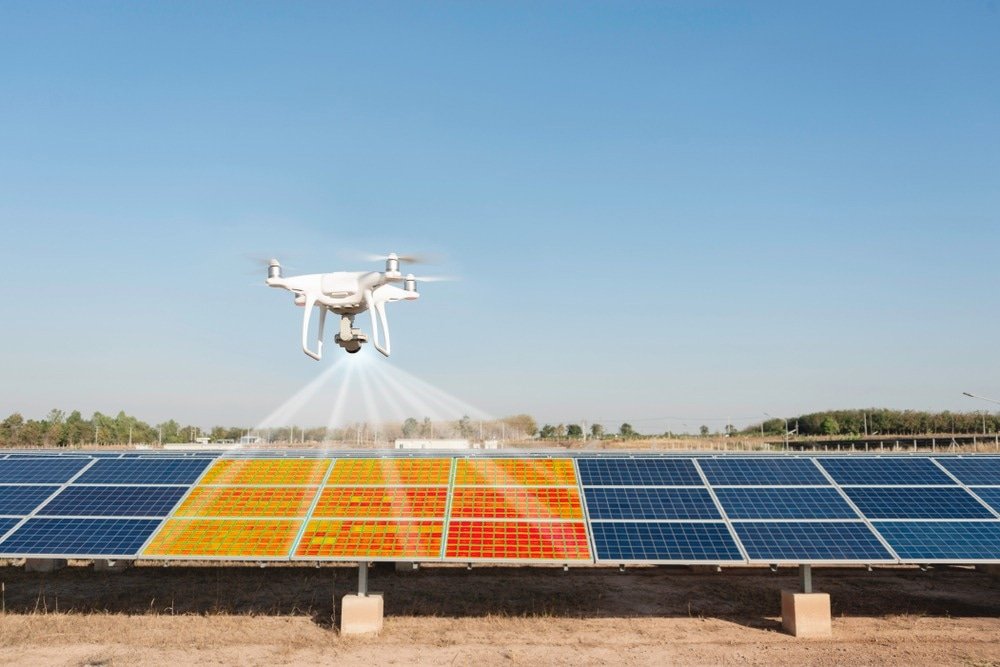
Construction progress monitoring with drones provides real-time updates, reducing manual inspections by 60%. Drones also perform inspections of bridges, pavement, and roofs, spotting defects without scaffolding or risky climbs. Solar panel inspections use thermal imaging to detect faults, minimizing downtime and maintenance costs. The Drone Life NJ explains the efficiency of thermal drone roof inspections.
Utilities & Infrastructure
For utilities, drones inspect power lines and pipelines, using thermal infrared inspections to identify heat leaks or corrosion without shutting down operations. This approach reduces inspection time by 50% and enhances worker safety by avoiding high-altitude risks. Infrastructure like dams benefits from drone data, creating 3D models for predictive maintenance, saving on repair costs.
Agriculture & Beyond
In agriculture, crop health assessment via drones with infrared sensors pinpoints irrigation issues, boosting yields while cutting scouting time. Thermal infrared inspections of roofs and pavement detect water damage or cracks, preventing costly repairs. Propeller Aero details how drones optimize surveying for construction and agriculture.
SkySurveyUSA.com delivers these benefits with expert pilots and advanced drones, saving you time and money while prioritizing safety. Contact us to revolutionize your next project with drone data!
Take flight with smarter solutions today!
Drones Revolutionize Construction and Property Management
Drones are transforming the construction, survey, and property management sectors, delivering precision and efficiency like never before. At SkySurveyUSA.com, our FAA-licensed pilots use advanced drone technology to provide stunning 4K UHD video and hi-res photos for commercial and residential projects. From construction monitoring to thermal inspections, our convenient and budget-friendly services—including the innovative SkySafe Property Report and SkyEye Aerial Walkthrough—prioritize safety and accuracy, reshaping how industries manage complex sites.
Construction Monitoring with 4K Precision
Construction monitoring reaches new heights with SkySurveyUSA.com’s 4K video and aerial photos. Our drones track progress on commercial sites like warehouses or residential developments, capturing detailed visuals from above. With RTK accuracy (Real-Time Kinematic), we ensure measurements are precise to the centimeter, aligning builds with plans. This reduces errors and keeps projects on schedule, a critical advantage in an industry where time is money. Statista notes drones are increasingly vital in construction, and we’re leading the charge.
Mapping and Volumetrics for Site Surveys
Accurate mapping and site surveys are foundational to construction and property management. Our drones generate detailed topographic maps and 3D models, enhanced by RTK accuracy. For volumetrics, we calculate stockpile volumes with precision, helping contractors manage resources efficiently. These hi-res photos and stunning 4K UHD outputs replace slow, costly ground surveys with a convenient, budget-friendly alternative, delivering actionable data for real estate and infrastructure projects.
SkySafe Property Report: Safety and Maintenance Insights
Our SkySafe Property Report is a game-changer for safety and maintenance aerial surveys. Using drones, we inspect commercial and residential properties—rooftops, facades, and more—without ladders or scaffolding. This FAA-licensed service includes 4K video and high-resolution stills, identifying structural issues or hazards with unmatched safety. Per SkySurveyUSA.com, it’s ideal for property managers needing thorough, visual documentation to maintain assets and ensure compliance.
SkyEye Aerial Walkthrough: Immersive Site Views
The SkyEye Aerial Walkthrough offers a dynamic perspective for construction and survey teams. This service provides a narrated stunning 4K UHD video tour of a site, showcasing progress or conditions from the air. As detailed on SkySurveyUSA.com, it’s perfect for project updates or stakeholder reviews, blending aerial photos with expert commentary. It’s a convenient way to share a site’s status without requiring on-site visits.
Thermal Inspections and Utility Checks
Thermal inspections are a cornerstone of our offerings, detecting heat leaks in roofs, wear in pavement, or faults in utilities. For utility inspections, drones scan power lines or pipelines, combining 4K video with thermal imaging to spot issues safely and efficiently. These budget-friendly methods, backed by FAA compliance (FAA), minimize downtime and risk, making them indispensable for property management and infrastructure maintenance.
Why SkySurveyUSA.com Leads the Way
SkySurveyUSA.com delivers drone solutions tailored to construction, survey, and inspection needs. With RTK accuracy, volumetrics, and specialized services like the SkySafe Property Report and SkyEye Aerial Walkthrough, we provide hi-res photos and stunning 4K UHD footage that drive smarter decisions. Our FAA-licensed operations ensure safety, while our convenient, budget-friendly approach supports commercial and residential projects nationwide. In an industry evolving fast, we’re setting the standard.
Explore how we can elevate your next project at SkySurveyUSA.com.
Industry Pros Use Drones for Maxiumum Efficiency and ROI
Drones are transforming construction, surveying, and property management with unmatched efficiency and precision. At SkySurveyUSA.com, our FAA-licensed pilots use advanced drone technology to deliver stunning 4K UHD video and hi-res photos for commercial and residential projects. From construction monitoring to thermal inspections, our convenient, budget-friendly services—including the innovative SkySafe Property Report and SkyEye Aerial Walkthrough—prioritize safety and accuracy, reshaping how industries manage complex sites.
Efficient Construction Monitoring with 4K Precision
Construction monitoring reaches new heights with SkySurveyUSA.com’s 4K video and aerial photos. Our drones track progress on commercial sites like warehouses or residential developments, capturing detailed visuals from above. With RTK accuracy (Real-Time Kinematic), we ensure centimeter-level precision, aligning builds with plans. This reduces errors and keeps projects on schedule, a critical advantage in an industry where time is money. Construction Dive notes drones are increasingly vital in construction, and we’re leading the charge.
Mapping and Volumetrics for Site Surveys
Accurate mapping and site surveys are foundational to construction and property management. Our drones generate detailed topographic maps and 3D models, enhanced by RTK accuracy. For volumetrics, we calculate earthwork volumes with precision, helping contractors stay on budget and schedule. These hi-res photos and stunning 4K UHD outputs replace slow, costly ground surveys with a convenient, budget-friendly alternative, delivering actionable data for real estate and infrastructure projects. Statista forecasts a boom in drone applications, positioning us at the forefront.
SkySafe Property Report: Safety and Maintenance Insights
Our SkySafe Property Report is a game-changer for safety and maintenance aerial surveys. Using drones, we inspect commercial and residential properties—rooftops, facades, and more—without ladders or scaffolding. This FAA-licensed service includes 4K video and high-resolution stills, identifying structural issues or hazards with unmatched safety. Per SkySurveyUSA.com, it’s ideal for property managers needing thorough, visual documentation to maintain assets and ensure compliance.
SkyEye Aerial Walkthrough: Immersive Site Views
The SkyEye Aerial Walkthrough offers a dynamic perspective for construction and survey teams. This service provides a narrated stunning 4K UHD video tour of a site, showcasing progress or conditions from the air. As detailed on SkySurveyUSA.com, it’s perfect for project updates or stakeholder reviews, blending aerial photos with expert commentary. It’s a convenient way to share a site’s status without requiring on-site visits.
Thermal Inspections and Utility Checks
Thermal inspections take SkySurveyUSA.com’s offerings to the next level. Using advanced drone-mounted thermal cameras, we detect heat leaks in roofs, stress points in pavement, or inefficiencies in HVAC systems. For utility inspections, drones scan power lines or pipelines with ease, combining 4K video with thermal imaging to spot issues safely and efficiently. These budget-friendly methods, backed by FAA compliance (FAA), minimize downtime and risk, making them indispensable for property management and infrastructure maintenance.
Why SkySurveyUSA.com Leads the Way
SkySurveyUSA.com delivers drone solutions tailored to construction, survey, and inspection needs. With RTK accuracy, volumetrics, and specialized services like the SkySafe Property Report and SkyEye Aerial Walkthrough, we provide hi-res photos and stunning 4K UHD footage that drive smarter decisions. Our FAA-licensed operations ensure safety, while our convenient, budget-friendly approach supports commercial and residential projects nationwide. In an industry evolving fast, we’re setting the standard.
Explore how we can elevate your next project at SkySurveyUSA.com.